Showing posts with label maps. Show all posts

Monday, July 27, 2020

Birmingham, AL: A Judgmental Map


I forget how I got here, but so glad I did: Birmingham: The Magic Sub-Reddit.

Among other whimsical, witty, and actually useful items, the forum introduced me to the Judgmental Map of Birmingham

Birmingham, ALby AnonymousCopr. 2014 Judgmental Maps. All Rights Reserved.
Judgmental map of Birmingham, Alabama. Credit: Judgmental Maps.


Of course, I immediately sought out my neighborhood on the map.

Of course, I'm not going to tell you where that is at this point, but I will say that I:
  1. Felt relieved that I hadn't moved to the "undiscovered bodies" neighborhood; and
  2. Raised an eyebrow and said to myself, "huh," when I saw the characterization of the one I did move to, with said "huh" signifying a long, "hmmmmm," about which even I'm not sure what I mean. 

My favorite designation is "angry retired engineers."

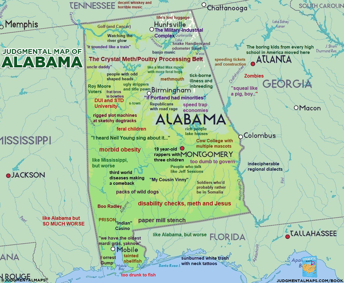
There's also a wicked judgmental map of Alabama, with sidebars on its neighbors:

Alabamaby AnonymousCopr. 2018 Judgmental Maps. All Rights Reserved.
Judgmental map of Alabama. Credit: Judgmental Maps.


My favorite Alabama designation: "Life's lost luggage."


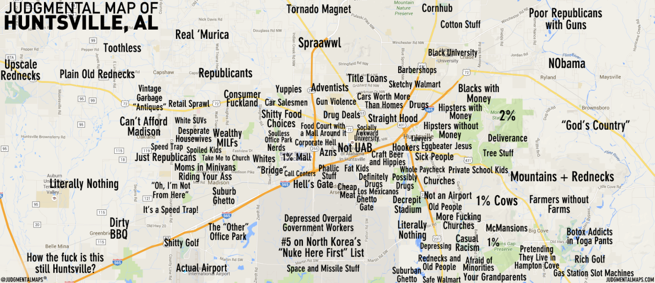
And Huntsville:


Huntsville, ALby Jacob and John R.Copr. 2016 Jacob and John R. All Rights Reserved.
Judgmental map of Huntsville, Alabama. Credit: Judgmental Maps.


The Huntsville map has a Republicants neighborhood, a designation I had to look up.


In 2013, I shared some maps that purport to show how Americans view the world.


St. Louis has a judgmental map, but it is only sad. Kansas City has one, and it is only mean. Missouri, I'm glad I divorced ye.


Thursday, September 5, 2019

Tucson, AZ: Samaritans: Topo Maps


Karr Canyon, New Mexico map. June 2013.


At a recent Samaritans meeting, professor emeritus Ed McCullough gave a brief lesson on how to read a topographic (topo) map.


The Bumble Bee, Arizona US Topo map
Topo map, the Bumble Bee, Arizona. Source: USGS.


Topo maps and GPS are important in the humanitarian work the Samaritans do. Through direct encounters with migrants on the move; through the discovery of human remains; through indirect, visible evidence of apparent migrant activity; and through second-party reports, Samaritans collect location data and record it. Topo maps and GPS devices assist Samaritans in returning to prior water placements and in making decisions about where to test new water placements. ... and, oh yeah, to not get lost in the desert.

The Tucson Samaritans have an inventory of hard-copy topo maps for the areas they cover.


Tbilisi map. June 2012.


Samaritans use the topo maps in conjunction with their GPS devices, which the Samaritans customize to reflect historical location data related to their mission.


Dubai map. January 2012.


You can be sure vigilante militias do the same.

In poking around about topo maps, I found a 2015 article, Designing a Topo Map For Search and Rescue. It's illuminating to learn how the elimination of utility lines on an updated USGS topo map might affect search and rescue efforts of first responders.

As I learn more about the deadly theater that plays out in the desert, and the people on the front lines - migrant peoples, Border Patrol, humanitarians, vigilante militias, coyote guides, Tohono O'odham Nation peoples, other borderland residents - and what a crap shoot it is to save lives with water in the right place at the right time - I think: Surely there are people who know with a reasonable level of certainty the trajectory a group of migrant folks will follow, depending on its departure point from Mexico.

If a coyote is leading a group, at what point, and with the guidance of whom, is the decision made to follow a certain path?

Is it true that the Border Patrol might track a group into the US early on, but let the group exhaust itself after several days of travel in arduous conditions before picking it up, jeopardizing the lives of group members?

If a group leaves from a widely-known departure point in Mexico, a border village, say, doesn't it stand to reason there are only so many paths a group can take in the first 20 miles or so into the desert? And therefore, in theory, make some educated estimates possible about where a group might first start hurting for water?

And if a humanitarian group deduces or receives advance intel about a group's general trek path, at what moment does the humanitarian group's act of mercy in the form of water and food, based on the use of that intel, become a crime of aiding and abetting?

Could a humanitarian group use reverse 'engineering' to predict travel patterns of migrants, based on where Border Patrol picked up groups in the previous 30 days?

Do algorithms exist that suggest how a group of people tends to make decisions at way points about which direction to go?

I'm sure more will be revealed to me as I get more educated. Because I sure as heck know that people smarter and more experienced than I are literally in the trenches (or in the desert: the washes) doing life-saving work every day.

Video tutorials on topo maps

Below is a quick-and-easy, chill tutorial from REI. I like the unrushed pacing of the narrator's speech, the timbre of her voice, and her plainspoken accent, all of which contribute to a pleasant tutorial experience.


Below is a longer lesson. Although five times as long as REI's tutorial, Seth Horowitz' lesson is smooth as cake in the mix of his friendly, accessible voice; an approximation of interactivity with fill-in-the-gaps exercises; the multiple examples of each concept; and the simplicity of his terminology and his economy of speech. Mr. Horowitz is an earth science teacher at a middle school, and the graded language and content for this lesson works just fine for me!


Sunday, August 14, 2016

Budget Road Trip: Don't Do This


Highway 36, Colorado. May 2016.

I don't think I'm being immodest when I say I'm an expert at budget road trips in the US.

I am very clear here about the worth of back-up paper maps on road trips.

In May, I embarked on a two-day, single-destination road trip from Missouri to Longmont, Colorado.

In past road trips to a single destination (versus open-ended, meandering trips), it was my habit to:
  • Plot out my route online, print the instructions, pop them into a crisp colored folder, and lay it on the passenger seat next to me; 
  • Carry an atlas in my car; and
  • Stop at the state welcome centers and pick up their respective road maps. 

Now that I'm in possession of a smart phone with a mapping app, all of the above are Plan Bs or ancillary tools to enhance the mapping app.

But for this trip, I suffered from everything I caution other road-trippers about, delivered in a cascade of fails:

Highway 36, Colorado. May 2016.


Complacency


The extent of my pre-trip route plotting consisted of a quick look at a map a day or two in advance. I noted that I could take I-36 almost all the way to my Longmont destination, and that I'd jog up a secondary road at some point before the metro-Denver traffic snarls. I saw a road that looked pretty good for that purpose, and tucked into my mind that I'd nail that down when I picked up a Colorado map at the state line or via my phone. [Note the foreshadowing via the bold orange text.]

I counted on "just-in-time" intel. Didn't even think about taking five minutes to nail it down right then and print off directions to my final destination address.

This would have been OK if I'd had an atlas in my car. But I didn't. 

Complacency!


Assumptions that didn't pan out


Ho!

Unpleasant surprise #1: There are no welcome centers on Interstate 36 in Kansas or Colorado.


NWNM Visitor Center. Grants, New Mexico. December 2012.


Unpleasant surprise #2: System failure


Inexplicably and without warning, my phone shut down my data access. Meaning: No mapping application, no texts, no google searches.

This occurred in Colorado just about at the point where I was wanting to know where I'd cut loose from Interstate 36 and jog north. Of course it did.

Fortunately, the phone feature actually worked, so I used two "lifelines" who talked me into my final destination. But damn, I was flying blind, and I didn't like that.

(After I arrived at my destination, I remembered I have an old-timey GPS device in my glove compartment. It's been gathering dust there for a couple of years, at least. Doh.)

Lessons learned AGAIN

  1. Follow the basics
  2. Remember that systems fail
  3. Fail smartly


Grand Canyon warning poster. Credit: National Park Service


Tuesday, June 30, 2015

Updated: Taking a Budget Road Trip, Part 4: Pack List

On June 24, 2011, I published Taking a Budget Road Trip, Part 4: Pack List. This was from my Take a Road Trip series.

Below is the updated version:

Road to Monument Valley. October 2007.

There are 6 categories for road-trip packing:

1.    Personal
2.    Picnic
3.    Road-trip comfort
4.    Emergency
5.    Camping, if applicable
6.    Tourist gear


Clothes drying on a tree branch. Rustavi, Georgia (Caucasus). September 2011.


Personal gear

Clothes - How much should I pack?

There should be an algorithm to calculate the answer to this question, considering:

Duration of trip + number of days you're willing to wear each clothing item before washing it + (un)willingness to wash clothes in sink or laundromat + diversity of temperatures on route + diversity of road trip activities, e.g. athletic, casual, or dressy.

Here's what works for me:
  1. If my road trip is for a week or less, I don't want to launder clothes on the road, so I'll bring enough to last the duration. 
  2. If my road trip is for longer than a week, I'll assume a trip to a laundromat and pack accordingly. Note: Most motels have coin-operated washing machine and dryers.
  3. I wear trousers for three days and a shirt for two days.
  4. I pack specialty items (e.g. a dressy outfit) in a separate bag and leave that in the car until I need it.
  5. If temperature variations are in play, then I think layers, and I also pack a coat or jacket. I usually keep temperature-specific items in the car til/if needed, rather than pack them in my main luggage.

If you over-pack, the main consequence is that it will be more of a hassle for you to find stuff, carry stuff, and fit it in with other stuff. Let your frustration threshold be your guide as to how much you want to avoid these consequences. Otherwise, road trips are forgiving to chronic over-packers.

Shoes

For God's sake, bring a comfortable pair of shoes! Uncomfortable shoes will keep you from doing or enjoying activities that you would otherwise love to do.


Something warm

No matter how warm the destination, there will always (ALWAYS) be a place that will freeze you out. A motel room. A restaurant. A museum. A nightclub. A cave.

Bring a sweater, sweatshirt, shawl, jacket - something - that will keep you warm when that happens.
If you fail to do this, do not whine about how cold you are. At your next opportunity, stop at a second-hand store and buy something.

Toiletry bag

My perfect bag:
  1. Has a little hanger or velcro loop design so I can let it hang from a towel rod or door hook. It won't get damp from a wet counter surface. It won't take up limited counter space.
  2. Has compartments that let me segregate cosmetics, dental care items, cleansers/lotions, and all the rest: deodorant, small scissors, mirror, comb/brush, tweezers, clippers. Three compartments needed at minimum, but no more than four.
  3. Fold/rolls into smaller mass for packing

eBags Weekender

Luggage

I love my lightweight, durable eBag Weekender bag for road trips. The outside and inside compartments maximize organization. Adding the three large eBag packing cubes maintains order, and if I pack the cubes so each has all that I need for one or two days, then I can just take the cube and my toiletry bag into the motel and leave the larger bag in the trunk.

If you looked at the price of this bag and blanched a bit – no worries. I invested big money in this bag because of my long-term needs. For a budget road trip, if you don’t already have luggage you like, then check out your local thrift stores such as Goodwill, Salvation Army, etc. and buy something that looks like it will work for you. Or borrow a bag.


Dirty laundry

Option 1 - I collect my dirty laundry in one of my packing cubes and keep it in my "weekender”

Option 2 - I toss it into a plastic or cloth bag and keep it in the trunk.

Either way, it's easy to lug it to a washing machine on the road or back at home.


Picnic gear

For now, let's assume camping is not involved. The purpose of the picnic gear is to let you enjoy good food and drink without having to go to a restaurant. It also lets you manage your time and itinerary - you can eat when you want, where you want.


Lunch on Jemez scenic road, New Mexico. August 2013.


Cooler

My perfect road-trip cooler is my old Igloo Playmate cooler (in photo above):
  1. Has a top handle for one-handed carrying
  2. Is large enough to hold one small bag of ice (i.e. 7 pounds) + 4-6 cans soda + food items for a couple of days (e.g. hard-boiled eggs, roast chicken or beef, cheese, some fruit, and carrots/celery)
  3. Is small enough to fit on the floor behind a front seat - and small enough that I feel comfortable replenishing the ice from a motel ice machine
  4. The lid slides open with the push of a button
  5. Because of the tent-like peak, I can over-load it a bit.

The exterior dimensions are about 14"x10"x13." That 13" is the height, which is misleading as it measures the peaked lid. The Playmate "Boss" seems to be the closest to my older model.

Unless I'm going to camp, this size cooler is fine for a road trip. There are grocery stores everywhere - no need to carry more than a couple of days' vittles at a time.


My camp box.


Camp box (or "chuck box")

I have a cool jeweler's sample box, made of fiber board, I think, bought at a flea market, that I re-purposed into a camp box. Important features include: 
  • It has a handle on top for one-handed carrying
  • The lid closes securely with two draw bolt latches
  • It has two shelves that are are deep/tall enough for me to place smaller, clear-plastic containers on them for organization 
  • It is sturdy
  • It's big enough to do the job, but small enough not to take up too much vehicle space

You can make a great one on your own using a clear plastic storage bin and smaller transparent storage containers within. Watch the dimensions; you don't want to go too big.

My camp box is always stocked with:
  • Salt and pepper
  • Plates (plastic washable/reusable or paper)
  • Utensils
  • Corkscrew
  • Can opener
  • Sharp knives
  • Table cloth
  • Cloth towel
  • Aluminum foil
  • Fire starter
  • Matches
  • Rope and clothes pins
  • Candles
  • Cups
  • Sanitizer
  • Recycled plastic grocery bags that I can use to collect and dispose of trash - these are tucked into an empty, cardboard paper-towel tube to conserve space 
  • Ziploc-style bags - quart size
  • Small bottle of dish washing liquid

Bag for consumable goods

In this bag, I throw dry items that I'll consume along the way, such as:
  • Bread
  • Instant oatmeal
  • Ground coffee
  • Paper towels
  • Three 1.5-2 cup, round, microwave-safe plastic containers with lids  - for oatmeal and other picnic-style menu items that require bowls

By using a bag instead of a bin or basket, I can collapse the bag after the items have been consumed, which opens up space in my car.

Bag for durable goods

This bag is for small appliances that I might never need during the trip. Depends on what's in the hotel rooms I end up in.
  • Small coffee maker and, depending on type, any accessories (e.g. filters)
  • Hot plate
  • Small pot with lid to heat things up in
  • Maybe you're a tea drinker and dislike the after-coffee taste of running water through the motel coffee maker. On a road trip, you can bring your own tea kettle or brew pot.

A sibling traveler, making himself comfortable.


Road trip comfort

If a road trip is intrinsically good (and it is), bringing familiar comfort items from home make it even better.

Some ideas:

Books: real, virtual, or audio. If you're a regular reader, this is a no-brainer. You know you'll bring reading material. If you're an occasional reader, consider a book that relates somehow to the places along your road trip path. Or a book about road trips. Here are a couple of road-trip reading lists, both from A Traveler's Library.

54 Road Trip Books and Movies (by state)
Top 5 American Road Trip Books and The List

And here's a literary perk of road trips (or any trips) --> This is the perfect venue for reading trashy, brain-candy crap that you secretly crave, but can't bring yourself to possess in your "real" life. Go ahead - buy that National Enquirer!

Favorite pillow - for car napping (especially when traveling with someone else) or for augmenting inadequate motel pillows

Blanket - not only does this fall into an emergency pack list, but if you're traveling with someone, it's nice to nap when you're not driving. Even in the summer, a blanket is comforting when the car a/c is on.

Good music - If, like me, you've got an older model car, invest in a cigarette lighter FM transmitter device to access your music player.


Emergency preparation
  1. Before you leave on a road trip, take your vehicle to an auto service shop and ask that they do a trip   check. Change your oil.
  2. Join AAA or a similar roadside assistance provider. Batteries drain. Starters die. You lock the keys in your car. You get a flat.
  3. Have a blanket in the car.
  4. Pack a flashlight in addition to the flashlight app you may already have in your smart phone.
  5. If you're traveling with others, bring your spare car key so that two of you have a key.
  6. Leave a rough itinerary with someone back home.
  7. Keep a jug of water in the car.

Grand Canyon campsite. September 2007.


Camping

If you're already a camper, you know what to bring, and you've probably already got the equipment.

If you're not a camper, don't be intimidated. Here are some easy-button basics for you to bring:

Tent. Unless you plan to do a lot of camping after your road trip, just get a cheap tent. Know that when the label says it's a two-man tent, that's a lie. Get a 3-man tent if there are two of you, and a 4-man tent if there are three of you. Get a dome tent. It will be easier to put up and you can pick it up and move it at will, until you stake it down. Do buy a tarp to go under the tent. These are also inexpensive and you can use them for other things in the future. Get a tarp that is a little smaller than the tent.

Sleeping bags. You can also get sleeping bags cheaply. Or borrow them. Or make bedrolls from blankets and a comforter.

Pillows. Do bring pillows from home - you'll be much more comfortable.

Socks and knit hat. Clean socks and a knit hat will help keep you snug in your sleeping bag and tent. Remember that cotton will not keep you warm.

Cook stove. Yes, you could build a fire and cook on that. ... BUT: It's not uncommon for a park to have a no-fire order. Buy or borrow a cook stove. (If you borrow it, return it clean.) Alternatively, you could skip the cooking altogether. Instead, pick up picnic foods that don't require cooking.

Cooler. If you plan to do a lot of multi-night camping on the trip, then consider getting a larger cooler to avoid spending too much time replenishing food and ice supplies. Weigh this carefully against the vehicle space it will consume for the entire trip. Another option is to just take an additional small cooler.

Light. At minimum, you'll want a flashlight for each person in your party. This is in addition to any flashlight app you have in your smart phone.

Check above for the list of things I stock in my camp box. All of these will come in handy if you camp.

If this article were about going on a camping trip, there would be a lot more detail. But this is about a road trip.


Tourist gear
  1. Camera (with extra memory card and an extra battery)
  2. Binoculars
  3. Spiral notebook or journal
  4. Pens
  5. Addresses of people to whom you want to send postcards
  6. Postcard stamps that you buy in advance
  7. Maps. Before I leave on a road trip, I pick up a U.S. atlas for less than $10 at a local Walmart. Then I pick up free state maps at each state's welcome center, which is usually the first rest area after you cross the state line. I recommend these even if you’ve got a smart phone with map and GPS features. Paper maps give you - literally - the big picture of where you're going, alternate routes, and where you might want to go. Also, phones fail. Satellite and tower connections fade in and out. The paper map is right there. 


See more details about gear in Part 6: Road Trip Technology.

To see all chapters of the Take a Road Trip, click on the tab of the same name at the top of the blog. Or click here.


Tuesday, March 17, 2015

Where the Hell Am I, Louisiana: The Map App


Part 1

A few years ago, I listened to a family member, let's call her Kiki, explain why she had not yet used the Onstar program in her new car. .... "Because it could take me into a dangerous area and I could end up DEAD!"

At the time, I thought two things:
  1. Paper maps could do the same thing; and 
  2. Hoo boy. 
But I kept my mouth shut.

It wasn't too long after that when Kiki was prevailed upon to try out her Onstar and she loved it!


Part 2:

So here it is March 2015, and I've got a smart phone now. On a fine weekend afternoon, I was fixing to drive from my new digs (oh, I haven't told you where I'm living now, have I?) to the village of Henderson which hugs a levee along the Atchafalaya River. I looked at about three route options on my map application, and selected one.

It was a pleasant day and my map app took me on a wind-y road, which was just fine with me. Then it wanted me to go over a bridge that wasn't there anymore, so I did a few circular maneuvers, asked a gentleman on the side of the road for some guidance, and he directed me to a way around that gone bridge, and then I was taken deeper and deeper into what reminded me of an old Stephen King story of the woman whose mission was to find the fastest way from Point A to Point B in Maine and her quest took her into a parellel universe where time got bend-y.

Until finally my map app carried me to what seemed to be an end of the road, on the other side of a wood-plank bridge with a PRIVATE PROPERTY sign posted, with my map app voice instructing me to go up the levee. Say what??

Near Henderson, Louisiana. March, 2015.


And it was at this moment that I thought of Kiki's dire predictions of murder and mayhem should she surrender herself to her Onstar.

Looking to my left, across the other bank of the bridge, I saw a group of men doing something along the river.

Having now read all of the Dave Robicheaux books (and having read Winter's Bone and watched the movie, based in the hinterlands of my own Missouri ), what might they be doing?  Running drugs for a South American cartel? Dispensing with a troublesome comrade? Or just fishing? Where's the ice chest to tell me all is as it should be?

Winter's Bone trailer:


"Talkin' just causes witnesses."

I crossed the wood-plank bridge with some trepidation and then asked one of the men, "I'm trying to get to Henderson from here ... but I'm confused about what I'm supposed to do now." One of the men said, "Well, you can turn on around here and go back the way you came ..... [insert my mental nervous swallow here] ... or you can go right and it'll take you 10 to 15 minutes to get there."

Because I am genetically programmed to not backtrack, I took a few moments to decide if "turn right" really meant "turn right" or did it mean "go up onto the levee and turn right?" Did the PRIVATE PROPERTY sign refer to the flat road to my right or the levee road up and to the right on the levee?

I chose the flatlander road on the right. When I say road, by the way, I'm talking gravel road.

This met with approval from my map app until a few miles down the road when it really, really wanted me to climb up onto the levee. Finally, I acquiesced and for some more miles drove on the gravel road up top, noticing that the flatland road kept on going on right beside me, down below. Eventually, I overcame the objections of my map app and got back down onto flat land.

All ended well, of course, but I took a different route home.  

I did see this pretty community of beehives on the way to Henderson:

Near Henderson, Louisiana. March, 2015.


Reminded me of Caucasus Georgia, on a visit to an agrarian technical school in Kachreti


Wednesday, May 29, 2013

Another Geography Lesson: Americans' Map of the World


To follow up on yesterday's geography lesson, I love these maps of the world as purportedly seen through the eyes of Americans. .... if we can't laugh at ourselves sometimes, then we're in trouble, right?

And note that I say laugh at ourselves - I don't support the sneering, condescending tone that some Americans adopt toward fellow citizens.

American map of the world. Credit: Cruise Critic forum


American map of the world. Credit: Intercultural Meanderings


Reagan's map of the world. Credit: Intercultural  Meanderings

Truthfully, it's kind of hard for me to laugh at the Reagan map of the world. Under his administration, we did (or enabled) some vile, despicable things in Central and South America. We denied desperate pleas for asylum from terrified Central Americans seeking refuge in the U.S. from death and torture because granting them asylum would have acknowledged that the governments we supported with financial and military resources were the perpetrators of said death and torture. It sickened me when George W. brought back players from that dark time to his administration, such as John Negroponte and Elliot Abrams.  Jesus, looking back on this is depressing. Not that I'm thrilled with Obama's apparent disinterest in restoring some civil freedoms we used to have in the U.S., before the so-called Patriot Act. 

OK, getting a grip .... 


American map of Asia. Credit: e-junkie info


There are also maps of the world according to other countries. Here's a view of the world by the British:

British map of the world. Credit: e-junkie info


Tuesday, May 28, 2013

Geography Lesson


My fantastic job of teaching English online has connected me to students in (so far):
  • China
  • Argentina
  • Italy
  • Germany
  • Brazil
  • Mexico
  • Spain

It have come to realize that I don't know shit about a lot of stuff in these countries. Like these countries' states or provinces. Often, my students - all adults - know the U.S. states.

An Ethiopian friend told me that when he was a child, all the kids learned about the U.S. states. In fact, there was a common phrase for when something got lost, "Where it'd go, Arkansas?" ... (if it was believed something was stolen, the question was, "it must have gone to Baghdad.") 

So I'm undertaking a project to learn the provinces of my students' countries.

China

Here's China in a reader-friendly visual:

Credit: SACU


Once I found a provincial map of China, my mind turned to land mass as compared to the U.S. Below is a nice graphic - note that it shows the comparison and also minds the latitudinal information. Note also that neither Hawaii nor Alaska appear.

Credit: Flora of China


One of my students told me that the area around Chengdu is particularly beautiful. Home of the pandas, too. And the five-color lakes.  It's in Sichuan province. Famous for its cuisine.


Argentina

Argentina has several states known for their regional wines.


Credit: La Vida Es Hermosa


If I compare China's size to the U.S., I guess I should do the same for Argentina.

Credit: Rand McNally


Mexico

Since I'll relocating to Mexico next year, I definitely need to get a handle on its states. Do you see the state of Michoacán? Yeah, that's where I was thinking of going, but maybe I've got to rethink that.


And the comparison between Mexico and U.S. land area:

Credit: Rand McNally


Below is a graph of expats who live in Mexico. I'm surprised the Canadian number is so low. Where do they go?
 
Place Country 2010 2000 1990
1  United States 738,103 343,591 194,619
2  Guatemala 35,322 23,597 46,005
3  Spain 18,873 21,024 24,783
4  Colombia 13,922 6,465 4,635
5  Argentina 13,696 6,215 4,964
6  Cuba 12,108 5,537 5,217
7  Honduras 10,991 3,722 1,997
8  Venezuela 10,063 2,823 1,533
9  El Salvador 8,088 6,647 2,979
10  Canada 7,943 5,768 3,011
11  France 7,163 5,723 4,195
12  China 6,655 2,100 1,161
13  Germany 6,214 5,595 4,499
14  Peru 5,886 3,749 1,633
15  Chile 5,267 3,848 2,501
16  Italy 4,964 3,904 2,397
17  Brazil 4,532 2,320 1,293
18  South Korea 3,960 2,079 1,161
19  Nicaragua 3,572 2,522 1,521

Other countries 43,799 37,126 32,487
TOTAL 961,121 492,617 340,246
Source: INEGI (2000),[20] CONAPO (1990)[21][22] and INEGI (2010)[23]


Italy

Back in the day, the first words that would come to my mind about Italy would be beautiful scenery, wine, good eating, rich history, and a people with a joie-de-vivre world view. Based on reports from recent travelers, the images that stick out most for me about Italy are crowds, heat, and high prices.

If you agree, then may I recommend a fine country for you to visit - Caucasus Georgia.


I'm kind of bored with the size comparison thing, so I'm going to stop on that.


Germany

One of my former (Caucausus) Georgian students is visiting Germany right now with a friend - they look to be having a fantastic time!

German provinces. Credit: Maps of Germany.


Do you see that pointy area in France below Saarland and to the left of Baden-Wirttemberg? That's Alsace-Lorraine.

Alsace-Lorraine. Credit: Travels in Europe With a VW Camper


My matrilineal and patrilineal ancestors passed through this area in centuries past, the maternal line being French Catholic, and the other Swiss Mennonite, aka Anabaptist (German-speaking), before their descendants, in different immigrant streams, in different centuries, ended up in North America. 

My maternal grandfather saw battle in Alsace-Lorraine during World War I.

Gee, what a detour I made.

So back to Germany. Because of my economic stratum, I tend not to think much about Western Europe as a travel destination - I can't afford to go, so it's just not on my radar.


Spain

Spain. Credit: Property net.


Jeez louise, the time it took to find a decent provincial map that also showed the almost-adjoining countries of Morocco and Algeria to the south of Spain (in English). Oh, you see they aren't there. Right. So anyway, see that land with the little airplane on it, south of Cadiz, practically touching? That's Morocco. If you look to the right along Morocco's coastline til you see the other little airplane? And then the yellow squiggly line? To the right of the squiggly line is Algeria.

The economic crisis in Spain right now is crushing. Recently, a British man bought an entire Spanish village (abandoned) for 60k euros. (There are villages like this in Caucasus Georgia, too.)


Brazil

Brazil provinces. Credit: emaps world


I always think of Brazil as being very big. Let's compare it with the U.S.

Brazil - US size comparison. Credit: Rand McNally

 Woo, yeah, it's big.
 
Although Brazil can boast tremendous advances in many areas economically, technologically, etc. it's also  suffering now in many areas. People don't feel safe. The government is perceived to be corrupt and ineffectual. There are some who believe the public school system is in awful shape, as there is no investment in bringing along new teachers for the public system, i.e. low pay and miserable working conditions. (Sounds like Caucasus Georgia, although there is ongoing reform.)

According to the World Atlas, Brazil's Sao Paolo is the ninth most populous city in the world at 20 million (just under NYC's 21.4 million and just over Mexico City's 19.4 million).