Sunday, September 8, 2019

Tucson, AZ: Samaritans: Artist Alvaro Enciso, the Crosses

Alvaro Enciso plants a Cross to honor a man who died seeking a decent life. Arizona. August 2019.


On a Humane Borders water run, I learned about Alvaro Enciso, an artist who has made it a mission to recognize the humanity of individual women, men, and children who have died in the desert in an attempt to claim a decent life.

Mr. Enciso honors the dead with painted wood Crosses that he plants into the Arizona soil.

Alvaro Enciso plants a Cross to honor a man who died seeking a decent life. Arizona. August 2019.

 Each Cross has a round red disk.

Alvaro Enciso plants a Cross to honor a man who died seeking a decent life. Arizona. August 2019.


The round red disk on a Cross represents a round red circle on the death map that Humane Borders maintains in partnership with the Pima County Medical Examiner's Office.


Each round red disk on the death map represents a woman, man, or child who died on their quest for a decent life.  Each round red disk on the death map corresponds to a precise geographic point on the planet where the human remains of a dream were found.

Alvaro Enciso plants a Cross to honor a man who died seeking a decent life. Arizona. August 2019.


There are so many collapsed dreams in the desert, individual collections of bone, sinew, skin, empty clothing, shoes, bags, papers. Maybe plastic baggies with garlic, dissolved in putrescence, to protect one from rattlesnake bites.

Garlic bulbs in a baggie, abandoned by a group of migrants, along with backpacks and other items, perhaps after pick-up by Border Patrol. Arizona. August 2019.


Most Tuesdays, Mr. Enciso leads a one- or two-car pilgrimage into the Sonoran Desert or adjoining highlands. He has selected the women, men, or children whose deaths he will commemorate on a trip, and he brings the day's Crosses with him. Sometimes he knows a fallen person's name, gender, and age; sometimes not.

The color of the painted Crosses vary according to the tint of the paint that someone donated to him or that he picked up somewhere on sale.

Democracy Now recently devoted a show to Mr. Enciso's mission, and I'll direct you there so you can learn more about his work in his own words: 


On the Cross pilgrimage I joined, there were small crews for ABC's Nightline and a freelance documentary company, and, I believe, a print journalist.

Alvaro Enciso plants a Cross to honor a man who died seeking a decent life. Arizona. August 2019.


In all, there were at least 10 of us. Upon arrival near the first site, several of us carried something that was a part of the planting - a bucket, a shovel, quickset concrete. And the Cross. I carried the Cross, grateful to do so. It didn't weigh much, and it felt well-balanced. It rested lightly in the crook of my right arm. I occasionally smoothed the wood with my left hand.

We walked, and I held the Cross, and I thought about this man who had died, and when we arrived at the spot where his remains had been found, it was .... gosh, it was so pretty. 

Alvaro Enciso plants a Cross to honor a man who died seeking a decent life. Arizona. August 2019.


Which doesn't surprise me like it might have long ago. When I think of the Rwandan Genocide, and my friend who survived that cycle of human madness, a question invariably comes to me: "Did birds continue to sing in the forest canopy above the screams of slaughter below"?

Of course they did.

The desert enchants and kills indiscriminately, thus a place for a pretty walk on a pleasant day for one is a place of death from heat stroke or thirst for another.

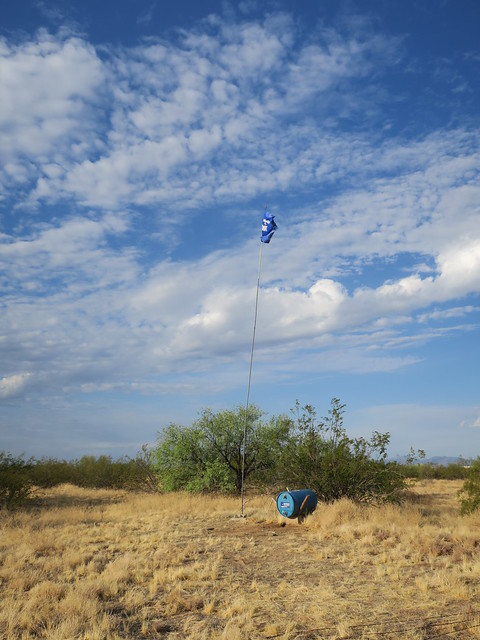
After Mr. Enciso planted the Cross in that grassy meadow, we embarked on a rather wild ride in the Samaritans' two SUVs up into the highlands, very close to the border. Mr. Enciso sought the last living place of another man, for whom he had brought a Cross. 

A man died in the saddle between those two peaks, in the search for a decent life. August 2019.


But this was not the day it would happen. See that saddle between the two mountains? There's a wide valley between there and the rise where we parked. Volunteer Samaritans would come another day and hike to the man's death ground.


Samaritans left water for women, men, or children who might pass through. A man died in the saddle between those two peaks, in the search for a decent life. August 2019.


The group left jugs of water in and under the shade of a tree, which looked across that valley. Maybe they will save a life. These jugs and barrels of water. They are an act of faith, or maybe more accurately, an act of hope in a lucky roll of metaphysical dice, that someone who needs water will see it and have still the strength to reach it. 


Below is a slide show with more photos from this trip with Mr. Enciso, plus the accumulation of photos from the water runs to the Sonoran Desert via Humane Borders and Samaritans.

Desert Water Runs


Saturday, September 7, 2019

Arizona: Sierra Vista: Our Lady of the Sierras

Our Lady of the Sierras, Sierra Vista, Arizona. August 2019.

Our Lady of the Sierras - another Arizonan couple compelled to build a church. "Another" in that some weeks earlier, a friend and I visited the Byzantine church on Mount Lemmon, in the town of Summerhaven.

Gosh, gorgeous views from the church.

Our Lady of the Sierras, Sierra Vista, Arizona. August 2019.


An intimate chapel.

Our Lady of the Sierras, Sierra Vista, Arizona. August 2019.


Creamy statuary.

Our Lady of the Sierras, Sierra Vista, Arizona. August 2019.


An imposing Celtic cross.

Our Lady of the Sierras, Sierra Vista, Arizona. August 2019.


One of my favorite design features is how the windows and votives frame the sky and valley.


Our Lady of the Sierras, Sierra Vista, Arizona. August 2019.


How peaceful it must be to sit in a chair during a service and gaze out the window, while listening to the voice of the Mass celebrants.


A slide show below of Our Lady of the Sierras and of other Sierra Vista sights:

Sierra Vista, Arizona


Friday, September 6, 2019

Arizona: Bisbee: Copper Mine


Lavender Copper Pit, Bisbee, Arizona. August 2019.


The colors and symmetrical planes of copper pits please my eye.

They gleam in hues of wet clay, spices, and semi-precious stones: Umber, saffron, cinnamon, caramel, amethyst. Ridged shelves rest on the mine's sloped sides like Andean terrace farms.

Lavender Copper Pit, Bisbee, Arizona. August 2019.


But they are mines, and over my entire life, from middle school through this very moment, I have been messaged that mines are bad. Environmental destruction and contamination. Company stores. Black lung. Miners trapped in collapsed or flooded mine shafts. Draconian responses (often with the assistance of law enforcement and local, regional, and national government bodies) against workers who demand sustainable, equitable compensation and safe working conditions. Corruption. The lack of meaningful oversight for environmental and social justice by entities outside of the mining industry. 


Lavender Copper Pit, Bisbee, Arizona. August 2019.


Nevertheless, we want to pull from the Earth substances we can fold into our lives. People want employment, too, to feed, clothe, and shelter themselves and their families.


Lavender Copper Pit, Bisbee, Arizona. August 2019.


Can we say that "fair trade" applies not only to us humans and our social communities, but also "fair trade" to the Earth - our water, soil, air, our brother-and-sister fauna and flora?


Lavender Copper Pit, Bisbee, Arizona. August 2019.


Here is a video on the importance of copper mining in the state's history:


The closing credits of the video acknowledge the contributions of two copper mine companies, Arizona State University, and a miners' story project housed in the University of Arizona. It is a video that addresses only the rosy attributes of copper mining, like a 1950s propaganda newsreel in a movie theater. A pity, as such a one-dimensional presentation disrespects the viewers, the taxpayers, and the dignity of women, men, and children who live and work around mines.

Is there such a thing as ethical mining?

Maybe.


The International Council on Mining and Metals purports to be about responsible mining, about mining with principles, for a "safe, fair, and sustainable mining industry."

The Mining Association of Canada adopted written principles to:
  1. Engage with communities
  2. Drive world-leading environmental practices
  3. Commit to the safety and health of employees and surrounding communities


Lavender Copper Pit, Bisbee, Arizona. August 2019.


The PEW Campaign for Responsible Mining (an "archived project" - circa 2009?) noted:
Mining of hardrock minerals—gold, uranium and other metals—on U.S. public lands is governed by the General Mining Law of 1872. Virtually unchanged since it was signed by President Ulysses S. Grant to promote development of the West, this frontier-era statute is no match for today’s modern mining. Under the 1872 law:
  • Mining companies—even those that are foreign-owned—are allowed to take approximately $1 billion annually in gold and other metals from public lands without payment of a royalty.
  • There is scant regulation of the nation’s top-polluting industry and few resources to clean up abandoned mines. The Environmental Protection Agency has documented more than $2 billion in taxpayer spending over the past decade on mine cleanup.
  • Mining is given priority status, on most public lands, making it nearly impossible to prohibit or restrict it, even near national parks and other iconic places, like the Grand Canyon.
The Pew Campaign for Responsible Mining is a national effort to educate and encourage the public and policy makers to adopt a modern framework for mining in the West. Today:
  • Taxpayers lose a conservatively estimated $100 million a year because, unlike with the coal, oil and gas industries, mining companies can extract valuable resources from public land essentially for free.
  • Taxpayers face a multi-billion dollar mining cleanup bill. According to the Environmental Protection Agency, the mining industry releases more toxic pollution than any other.
  • Federal agencies give hardrock mining on public lands priority status over other uses. It remains nearly impossible to restrict mining near national parks. Important water sources, wildlife and local communities are also vulnerable.
  • The law allows claim holders to buy public land for $5 an acre or less, and to use it for anything from condominiums to casinos. Congress has temporarily halted the practice.
Worse yet, a new rush is on in the West. In recent years, mining claims for uranium, gold and other metals on public lands have increased dramatically. Many of these new claims lie near treasured national lands, as well as highly populated urban areas and tribal lands.


Proposed Rosemont Copper Mine Near Tucson

In August 2019, a US District Court delivered a ground-breaking decision related to the proposed Rosemont Copper mine in the Santa Rita Mountains by the Canadian company, Hudbay Minerals:

For decades, the U.S. Forest Service has said it can’t say “no” to a mine on its land.

Now, the recent federal court ruling overturning approval of the Rosemont Mine on service land near Tucson will make it harder for the Forest Service to say “yes.”


... The ruling could chill the hard-rock mining industry that has lived under a generally favorable legal climate since Congress passed the 1872 Mining Law to encourage mineral exploration of public lands. .... 
Source: Tucson.com


A consortium of entities filed the motion against the Rosemont Copper mine.


Arizona Public Media attempted to explain some of the conflicts around the Rosemont Copper mine proposal in this May 2019 interview with a long-time, local journalist:


Related posts


Below, a slide show of my copper mine photos in Arizona, Texas, and New Mexico:

Copper mines


Thursday, September 5, 2019

Tucson, AZ: Samaritans: Topo Maps


Karr Canyon, New Mexico map. June 2013.


At a recent Samaritans meeting, professor emeritus Ed McCullough gave a brief lesson on how to read a topographic (topo) map.


The Bumble Bee, Arizona US Topo map
Topo map, the Bumble Bee, Arizona. Source: USGS.


Topo maps and GPS are important in the humanitarian work the Samaritans do. Through direct encounters with migrants on the move; through the discovery of human remains; through indirect, visible evidence of apparent migrant activity; and through second-party reports, Samaritans collect location data and record it. Topo maps and GPS devices assist Samaritans in returning to prior water placements and in making decisions about where to test new water placements. ... and, oh yeah, to not get lost in the desert.

The Tucson Samaritans have an inventory of hard-copy topo maps for the areas they cover.


Tbilisi map. June 2012.


Samaritans use the topo maps in conjunction with their GPS devices, which the Samaritans customize to reflect historical location data related to their mission.


Dubai map. January 2012.


You can be sure vigilante militias do the same.

In poking around about topo maps, I found a 2015 article, Designing a Topo Map For Search and Rescue. It's illuminating to learn how the elimination of utility lines on an updated USGS topo map might affect search and rescue efforts of first responders.

As I learn more about the deadly theater that plays out in the desert, and the people on the front lines - migrant peoples, Border Patrol, humanitarians, vigilante militias, coyote guides, Tohono O'odham Nation peoples, other borderland residents - and what a crap shoot it is to save lives with water in the right place at the right time - I think: Surely there are people who know with a reasonable level of certainty the trajectory a group of migrant folks will follow, depending on its departure point from Mexico.

If a coyote is leading a group, at what point, and with the guidance of whom, is the decision made to follow a certain path?

Is it true that the Border Patrol might track a group into the US early on, but let the group exhaust itself after several days of travel in arduous conditions before picking it up, jeopardizing the lives of group members?

If a group leaves from a widely-known departure point in Mexico, a border village, say, doesn't it stand to reason there are only so many paths a group can take in the first 20 miles or so into the desert? And therefore, in theory, make some educated estimates possible about where a group might first start hurting for water?

And if a humanitarian group deduces or receives advance intel about a group's general trek path, at what moment does the humanitarian group's act of mercy in the form of water and food, based on the use of that intel, become a crime of aiding and abetting?

Could a humanitarian group use reverse 'engineering' to predict travel patterns of migrants, based on where Border Patrol picked up groups in the previous 30 days?

Do algorithms exist that suggest how a group of people tends to make decisions at way points about which direction to go?

I'm sure more will be revealed to me as I get more educated. Because I sure as heck know that people smarter and more experienced than I are literally in the trenches (or in the desert: the washes) doing life-saving work every day.

Video tutorials on topo maps

Below is a quick-and-easy, chill tutorial from REI. I like the unrushed pacing of the narrator's speech, the timbre of her voice, and her plainspoken accent, all of which contribute to a pleasant tutorial experience.


Below is a longer lesson. Although five times as long as REI's tutorial, Seth Horowitz' lesson is smooth as cake in the mix of his friendly, accessible voice; an approximation of interactivity with fill-in-the-gaps exercises; the multiple examples of each concept; and the simplicity of his terminology and his economy of speech. Mr. Horowitz is an earth science teacher at a middle school, and the graded language and content for this lesson works just fine for me!


Wednesday, September 4, 2019

Arizona: The State Flag

Flag of Arizona.svg
Arizona state flag. Source: Wikimedia.


Like New Mexico, Arizona has a state flag with an eye-catching graphic. It's a perfect image for branding. Easy on the eyes, easy to remember, easy to replicate, easy - and cool looking! - to tattoo on one's flesh. All of the flag details are discernible from a distance, thus the image lends itself well to bumper stickers, caps, and t-shirts, making one want to declare one's pride of home place.

From the Arizona State Library:
Arizona's state flag is divided into two halves. The top half consists of thirteen alternating red and yellow rays which represent America's thirteen original colonies.

Because Arizona is a western state, the rays shows a setting sun. The colors of the rays refer to red and yellow in the Spanish flags carried by Coronado when he came to Arizona in 1540.

The bottom half of the flag is a solid blue field, the same color as the blue in the United States flag.

A large copper colored star is superimposed in the center of the flag. This identifies Arizona as the largest producer of copper in the United States.

I contemplated the attractive simplicity of Arizona's flag the other day as I compared it to the over-designed and sometimes puzzling flags of other states. I'm looking at you, Missouri, with your two standing grizzlies that no one thinks about in conjunction with Missouri.  Not to mention that flying knight's helmet, another bear, an eagle, a quarter moon, and all those stars.

Time to rebrand with something simple, like a river. Hell, two rivers, even! Open a re-design contest to tattoo artists - they'll know what will sell.


Missouri state flag. Source: Wikimedia.


Tuesday, September 3, 2019

Planning: 2020: Road Trip to Alaska


Kazbegi, Caucasus Georgia. May 2012.


Pssst. Over here. I've got a plan for a road trip after I leave Tucson, but I don't want the Universe to get wind of it yet.
.
You know how it likes to shake things up when mortals presume to think ahead.

But here 'tis: I want to do a reprise of a road trip to Alaska that I took with my daughter when she was 16. A l-o-n-g time ago. Wait, not that long ago. How old do you think I am, anyway?

I've got Plans A, B, C, and X for who might go with me. Plan C is I do it solo. Plan A includes one or two descendants. Plan B is a tried and tested travel partner with whom I've shared adventures and misadventures in the past. They are already acquainted with my quirks, both good and bad, as I am with theirs. Plan X represents an unknown variable for the trip.

This page is to collect places that might dot the route.


Alberta

Dinosaur Provincial Park. Dinosaur bones just laying around! My kinda place! A video teaser below:


I'm a little sheepish about my desire to go to this place, because mostly what attracts me is its name: Head-Smashed-In Buffalo Jump. But since it's a World Heritage Site, I can allege loftier motives. It's been on my some-day list for decades. Maybe this will the time.


Arctic Circle

My daughter and I flirted with the idea of going to the Arctic Circle on our road trip, but the time investment for the detour didn't fit well into the overall amount of time we had for our journey.

Maybe 2020 is the year to make it happen.

Arctic Circle. Source: Wikimedia.

Monday, September 2, 2019

Flashback: Istanbul: Back and Forth and the Basilica Cistern


Should I be embarrassed that sometimes I laugh at my own jokes? Yeah, I don't care.

I chuckled when re-reading about my day in antiquity and modernity in Istanbul circa 2012. My self thinks I'm good company with me.

Thursday, July 5, 2012


Istanbul: Back and Forth and the Basilica Cistern

Istanbul, Basilica Cistern, Upside-Down Medusa. July 2012.


Basilica Cistern

I'm a terrible tourist, maybe. There are Very Important Historical Sites here and I think perhaps I don't have the proper appreciation.

The Basilica Cistern, for instance.

Istanbul, Basilica Cistern, July 2012.


Maybe I want to be like Madonna - when she came to Istanbul recently, reportedly she went to the historic sites, alone (well, with her entourage), sans unwashed masses, after hours. That would be nice. You can do this by going on a virtual tour here.

Istanbul, Basilica Cistern, July 2012.


But instead I mingled with clutches of other tourists intent on taking photos of each other in the almost-dark. Mood music emanated from somewhere back by the Medusas to enhance our experiences. There was a cafe at one corner. There was an area (for 5 euro) to get your photos taken in authentic-like Ottoman garb. Kind of like those sepia saloon photos you can get at Silver Dollar City and the like.


Istanbul, Basilica Cistern, July 2012.


Obviously, I'm an elitist at heart. I want to go by myself, without the mood music, with it all so quiet, you can hear the fish open their gills. Yes, there are fish.


Back and forth

Alican had kindly offered to show me where and how to get a transportation card and we'd agreed to meet in front of his family business at 5:00 p.m.

I thought I'd planned my day for my usual getting-out-late routine to have lunch, then the Basilica Cistern, and then a short people-watching sojourn in the nearby park before meeting Alican.

First, I had yet another misfire of a lunch with only myself to blame, and second, I had miscalculated how long it would take to accomplish this and my Cistern visit. Consequently, I cooled my heels for over an hour in the park. But some good things came out of that: 
  1. It was shady and cool. Pleasant. 
  2. I discovered a fantastic ice cream bar - far superior to the so-called handmade whatever that I'd tried - it was chocolatey to the extreme. 
  3. I came up with a good response to future touts who decide to sit next to me on a park bench while I'm minding my own business, asking me stupid-ass questions, with the penultimate one being, "are you married"? My new response: "I don't answer such questions." I'm thinking of reviving the word "impertinent."
Eventually, Alican and I met up and he escorted me to a kiosk where I was able to purchase a ticket good on the trams, buses, and funiculars.

Alican returned to work and I set out on my plan to take the Bagcilar-Kabatas (T1) tram from Point E to Point A and then Point Z and then Point C, closest to my base. Or something like that.

So here's a video of part of my ride. You can feel how close the tram is to the sidewalks and pedestrians:


First I went over the Galata Bridge to the last stop at Kabatas. I got out of the tram and walked down the stairs into an underground mall similar (but less gritty) than those in Tbilisi.

Underground mall, Istanbul. July 2012.

 
Burbian Generica

On my return trip, after re-passing the historic stuff, we headed out to the burbs. Lots of apartment blocks - like New Rustavi, really, except prettier.  A moving snippet below:


And then, just as I was getting really hungry for dinner, we approached an outlet mall with signage for several familiar eateries. Surely, the fare had to be better, at a more reasonable cost, than the pseudo-Turkish stuff in Sultanahamet.

And so it was. There was a food court that one could drop in any suburban area in the world. Yes, the comfort of middle-class anonymity. No hustlers, no one wanting to know my name, no one pushing a menu toward me. Nope, just good ol' friendly customer service.  And all in quiet, four-tiered, air-conditioned splendor. 

Food court at mall, Istanbul. July 2012.

The land of bland. I embraced it. As one of my TLG colleagues used to say, "Don't judge me."


So if you're in Istanbul during the summer and looking for an escape from the heat, the hustlers, the hype, take the T1 tram toward Bagcilar and get off at this station:

Tram stop, Istanbul. July 2012.


 for this outlet mall:

Kale Outlet Mall, Istanbul. July 2012.

Sunday, September 1, 2019

Word of the Year 2019: Action: A Refugee Shelter


Casa Alitas in the old monastery. Tucson, Arizona. July 2019.


Casa Alitas is a shelter for refugees in Tucson. It's a beehive of hope administered by Catholic Community Services of Southern Arizona, overseen by a handful of paid staff, but kept buzzing by a swarm of volunteer worker bees.

When I hit Tucson in the spring, Casa Alitas was in an old monastery on Campbell Street.


Casa Alitas in the old monastery. Tucson, Arizona. August 2019.


Orientation


At the volunteer orientation I attended in early June, I heard these statements from the presenters (some paraphrased by me) about the women, men, and children who arrive at Casa Alitas. Assume that any factual errors are mine, due to misunderstanding on my part, and not the presenters' errors.
  • The City of Tucson opened two shelters for a few days, and stopped the sending of refugees to Casa Alitas, but after about three days, realized it was out of its depth. 
  • Border Patrol (BP) and Immigration and Customs Enforcement (ICE) used to give Casa Alitas advance notice of numbers and a list of names of incoming refugees, but sometimes now we might only get 15 minutes advance notice of incoming guests and no idea of how many people to expect. 
  • BP/ICE make a LOT of mistakes on the paperwork they give to the refugees they process. Sometimes the year is wrong, for example.
  • We didn't used to need security guards at the shelter, but anti-immigration activists have entered the monastery campus for intimidation purposes.
  • [At the time of this early-June orientation] the shelter transfers out 50-60 refugees per day toward their destinations within the US.

"[Upon arrival], we remove the Border Patrol (BP)/Immigration and Customs Enforcement (ICE) bracelets because they are not numbers anymore; they are a person."

"We reassure them they are in the United States. Often they have been moved from one place to another by BP/ICE, without being told where they are going, so they don't know if they were taken back to Mexico or where they are."

"[Upon arrival] we give them chicken soup, because often they have had little to eat for a long time. They will get sick if we give them flour (which they are unaccustomed to) or if we give them too much to eat too soon."

"Some adults enter the US for asylum not only with their children, but nieces or nephews whose parents were killed. Often they don't have the 'right' documentation to prove their relationships. So the nieces or nephews are separated from their guardians and taken to other locations."


The overarching message I received from orientation was this: The refugees are our guests and we shall treat them as such.


Casa Alitas in the old monastery. Tucson, Arizona. July 2019.


Volunteers come from around the US

One day when I reported for a volunteer shift, I met a group of women and men who'd come down to Tucson from Colorado Springs for the sole purpose of volunteering at Casa Alitas for a week. All day, every day, they volunteered.

I also met a registered nurse from New York. She and her husband were semi-full-time RVers who, while they lingered in Tucson, volunteered at the shelter a few months earlier. They eventually returned to their New York home base, but she couldn't stop thinking about Casa Alitas. So she came back alone, this time making her temporary home in a room at the monastery. 


A herculean operation

Some days, more than a hundred refugees arrived at the shelter. 

I so admire the coordinators who somehow make it all work. And the volunteers who donate goods and time, who cook and who serve meals, and who sort clothes, and who help guests find the clothes and shoes in the right sizes, and who provide medical care, and who drive people to the bus station, and who offer a safe place for guests to fall asleep with one's family. And who honor their dignity.


The monastery closes and a new shelter home opens


At the end of August, Casa Alitas moved to a county-owned facility. More on this in another post.

By the end of its tenure in the old monastery, the shelter's security had to be tightened almost to a lock-down mode because of the threatening presence of anti-immigration activists.