Tuesday, March 12, 2013

Take Me To Your Trogon


I poked around the New Mexico bootheel recently. I visited:

As I drove on the Cave Creek Canyon road, I saw a homestead that identified itself as Trogon Ranch. And I thought, what? A science fiction fan? Or maybe there were Trogons in the J.R.R. Tolkien series? Or a subgenus of troglodytes?


I knew my guesswork was probably off track when I took a side road and saw a sign instructing people not to engage in recording, as it might disturb the trogons. Who were here. This was odd to me, because I couldn't figure out why a silent operation such as recording would disrupt anything. Maybe these trogons were such sensitive creatures they could "hear" the barely-perceptible air-disturbance of recording equipment in action? Did this include video recording from my point-and-shoot camera? For real? 

It wasn't til later, after I'd turned into the Southwestern Research Station, and asked the gift-shop woman about this recording business that she solved the mystery. The trogons are birds, much sought after for viewing by birders, which range from their northernmost point, in the Chiricahua Mountains, to Costa Rica.  As for the recording business, evidently birders will project previous recordings of, say, female trogons, in order to elicit the calls of male trogons. So the sign referred to the full process of recording  - the sending out of a false call in order to attract real trogons - that disturbs trogons. Ohhhhhhhh.

So now for the big reveal, I present an Elegant Trogon:

Elegant Trogon. Credit: Dominic Sherony via WikiMedia Commons


A few accounts about the trogons from birders:

Vera Walters tells an engrossing story of trogons in a 1997 issue of Bird Watching Daily: Searching for Trogons in the Chiricahua Mountains of Southeastern Arizona.

John Yerger, of Portal, Arizona, shares his experiences during the 2011 trogon count in his blog, Adventure Blogging, in this post: After the Fire: Cave Creek Canyon, Trogon Census.

Another Portal resident, Narca Moore-Craig, describes her delighted sightings of the trogons in this series of her blog, Art & Other Adventures with Narca. Her title painting is lovely.

Monday, March 11, 2013

Rockhound State Park, NM: Spring Canyon Jewel


Rockhound State Park, Spring Canyon section, New Mexico


There are two parts to Rockhound State Park --> the park "proper" with the visitor center and campground, and then the Spring Canyon section, which is for day use only, a few miles away.

Rockhound State Park, Spring Canyon section, New Mexico


Spring Canyon is a tiny jewel in New Mexico's park system. It is a spectacular place to enjoy a picnic lunch. There's a pleasant trail up to Lover's Leap.

Rockhound State Park, Spring Canyon section, New Mexico

I didn't have much time to linger in the visitor center over at Rockhound proper, but it is a pretty building with an interior that feels refreshingly cool.  The park must be popular with campers, as it appeared filled up with various-sized RVs.

For me, Rockhound felt like a smaller, tighter version of Oliver Lee Memorial State Park outside of Alamogordo, but with Oliver Lee feeling roomier and with a more expansive basin view. On the other hand, I'm guessing that Rockhound at night is a fantastic location for night-sky viewing, as it is farther away from Deming than Oliver Lee is from Alamogordo, the military base, and some tiny communities nearby. 


Sunday, March 10, 2013

Lordsburg, New Mexico: Trains 'n Trucks

Lordsburg, New Mexico


Trains and trucks perhaps define Lordsburg, New Mexico.

The old commercial part of town, Motel Boulevard, faces the tracks.

New hotels and the restaurant chains face Interstate 10.

Driving west on I-10 on my way to Rodeo, I took this movie of the interstate, ribbons between the mountain ranges:


Driving east on I-10 when I left Lordsburg to return to Alamogordo, I took this movie of a train:


Just to lay any concerns to rest, I'm not looking out the side window while I'm driving - my camera is.

Saturday, March 9, 2013

Cave Creek Canyon, Arizona: Shining Colors

Cave Creek Canyon, Coronado National Forest, Arizona


Normally, I don't push the colors of my pics via my photo management application unless I'm being artsy, but in the case of the rhyolite bluffs in Cave Creek Canyon, it was necessary to push hard so I could show you how colorful these rock formations are in real life. Indeed, when I look for good images of the bluffs on the web, I find the same weak representation of my untouched photos. In real life, the rhyolite are a startling, shining orange, yellow, and green.

Cave Creek Canyon, Coronado National Forest, Arizona


Cave Creek Canyon is part of the Coronado National Forest. The national forest straddles New Mexico and Arizona.  

Cave Creek Canyon, Coronado National Forest, Arizona


I'd seen a sign back at Rodeo, NM, for the Wonderland of Rocks, which sounded cool. The Portal librarian told me getting there would require going over the mountain and it had been closed because of snow, last she'd heard. So I allowed as how I'd just see how far I could get and enjoy the view along the way. "Along the way" being Cave Creek Canyon.

Cave Creek Canyon, Coronado National Forest, Arizona


Shortly after departing Portal, I came to a fork in the road. To the right was Paradise; to the left, Cave Creek Canyon.  (Foreshadowing: I would have another opportunity to go to Paradise later.)

Cave Creek Canyon, Coronado National Forest, Arizona


I took the fork to the left, leading me into the Coronado Forest, a world of high, tri-colored bluffs on both sides of the tree-canopied canyon. I saw the giant maws of caves that scooped into the bluffs.


I passed a number of campgrounds, sadly, most closed. Although it was Saturday, the park office was also closed.

Cave Creek Canyon, Coronado National Forest, Arizona

There was a large sign cautioning users that smugglers and illegal immigrants frequented the territory.


Presently, I left the pavement and continued on gravel. I came up to the Southwestern Research Station, and turned in to check it out. The station is owned by the American Museum of Natural History. Academic and amateur birders come here from all over. The woman in the gift store explained to me that this little corner of the U.S. is a special place: It is the northernmost point of migration for many birds that come from the south; it is the southernmost point of migration for many birds that come from the north; and it marks the traditional boundaries for many eastern and western birds. WildBird Magazine ranks this area as the 3rd best birding location in North America.

After using the facilities, I continued my way up the mountain road. Saw a sign noting that 18 more miles til ... I forget what. Pavement?

Eventually, I arrived at what I thought might be the mountain summit. No snow, cool.

Mountain Road, Coronado National Forest, Arizona

 Until there was.

It was just a little, so I continued on. And then the dirt road got muddy and slippery and then there was more snow and then, sheesh.  Oh, good, I see a stop sign and a road sign pointing to the right --> Paradise. Only five miles or so. I saw snow going forward. Snow turning right.

Given my antipathy toward backtracking, I took a s-l-o-w and slippery right down onto the road to Paradise. That way led into the sun, I knew, from when I encountered that fork in the road. And as I slipped and slid a bit in the mud and saw more snow ahead - with the road going down, I reconsidered my not-turning-around history.

Cave Creek Canyon, Coronado National Forest, Arizona


As I did at the Antelope Wells portal, I paused. [Note: Long time ago, I read an article that it's the people with the most vivid imaginations who have the keenest phobias. I don't know if there's truth in that.] I considered what it might be like to get stuck in a muddy, slippery road overnight on a road that may not see traffic every day. And I thought about bears. I thought about how I would make a 3-point turn on a slippery-slidey muddy road with a drop-off on one side and a bluff on the other, about whether I should continue on. Oh, and did I mention that I have kind of a phobia about driving in snow?


Cave Creek Canyon, Coronado National Forest, Arizona


OK, yes, so it was a little scary (because I am a wuss), but I successfully backtracked and went back down the mountain. I passed a red car with three people in it - who'd also been at the Southwestern Research Station - going where I'd just come from. We paused to say, hey, and I explained that thar was snow further up and I'd turned back - but I acknowledged my wussdom. Later, when I was down in the flats and had gotten out for a walk, I saw them returning - they'd also turned back.

Once I hit pavement again, I took this movie - note the deer at about :38.


Here's a handy guide to the area.

This had been a big, beautiful day: Rodeo, Portal, Cave Creek Canyon, and the Mountain Road.

Cave Creek Canyon, Coronado National Forest, Arizona


I could see myself returning to this area in the future.

Friday, March 8, 2013

Alamogordo: Nesting Doves


My neighborhood abounds with doves. Some I know to be mourning doves by their call; others I don't know.

Nesting doves, Alamogordo, New Mexico

Nesting doves, Alamogordo, New Mexico

Nesting doves, Alamogordo, New Mexico


I admire these trees, which I'll refer to as palm yuccas (perhaps they are yucca faxonia). They can shelter scores of small birds, who hide within the greenery completely; you only know they're inside because of their chatter.

Thursday, March 7, 2013

Portal, Arizona, from Rodeo, New Mexico

Portal, Arizona


I didn't plan to step over into Arizona on my New Mexico bootheel weekend, but it turns out that Rodeo, New Mexico, and Portal, Arizona, are close sisters geographically, socially, and economically. I did drop some money in Rodeo (at the Chiricahua Desert Museum and the Rodeo Grocery and Cafe), contritubiting my small bit toward New Mexico's economic health, but then popped down the road to Arizona.

I liked this interesting fence feature on the road, which is Highway 533 :


The owner of the same fence perches abandoned shoes atop the fence posts.

Highway 533, between Rodeo, NM, and Portal, AZ

Highway 533, between Rodeo, NM, and Portal, AZ


It wasn't too long before I saw that ....whoa. What a difference six miles can make. 
  • Rodeo, sun -- Portal, shade.
  • Rodeo, desert -- Portal, deciduous.
  • Rodeo, austere -- Portal, cozy, inviting.
  • Rodeo, a little depressed -- Portal, cheery, more prosperous

Portal, Arizona


But, lo, the fortunate individual who lives in one or the other, according to her personal taste - the luxury of having two such different climates within 20 minutes of each other! Tired of a Rodeo's stern sun? Go six miles over to Portal and sit under the maternal arms of a giant cottonwood tree. Does your eye crave a change in your town's color palette? Move from the steadying gravitas of Portal's deep red buildings to the airy, light pastels in Rodeo. Enjoy the canopy of tree cover during the day in Portal, but want the open starry skies at night? You got it in Rodeo.

Portal, Arizona

Notwithstanding my deep love for the subtle, soft colorings of the high desert in New Mexico, and for New Mexico's grand sweeps of land bordered by mountain ranges, I am at heart a shade-loving girl, so I was immediately drawn to Portal. In fact, I had the sense I'd been here before.

Portal, Arizona


Part of Portal's charm also is that it is organized around a square of sorts, with several natural gathering spots for residents. There's the cafe, of course, which has a fenced courtyard. There's the New England-ish library that sits prettily behind an immense, white-skinned cottonwood, with the book return trolleys taking in some fresh air on a fine, warm day. A miniature bird "sanctuary" is adjacent to the library.

Portal, Arizona

 There's a post office, too, with signs outside announcing various community news.

Portal, Arizona


In fact, damned if there wasn't a flyer for tai chi classes! Something I've been on the lookout for in Alamogordo, to no avail thus far. Consider that: A city of 35k and no tai chi, versus a village of less than 100 probably, with tai chi.


I walked into the library; the librarian was there (who lives south of Rodeo, by the way). What a welcoming space.

Portal, Arizona


Portal, Arizona


The Portal, AZ -- Rodeo, NM website offers a friendly look-see into what life in Rodeo and Portal might be like. If I go by photos, the twin towns look like a very pleasant haven for peri-boomers and boomers. Portal, in particular, seems to have a strong community ethic. ... I wonder how reliable and fast its internet speed is?

I explained to the librarian that I'd like to get into the Coronado Forest, but that it hadn't looked too accessible in NM. She told me that if I continued on my road into Arizona, just a short way, it would be well worth my while ....

Wednesday, March 6, 2013

Rodeo, New Mexico

Rodeo, New Mexico


Getting to Rodeo

The day after I went to Rodeo, New Mexico, I ran into a gentleman who claimed Rodeo is known to have the darkest skies in New Mexico. If so, that's saying a lot, because there are a lot of places in New Mexico with dark skies.

It is in an area that attracts birds - and birders.

But I'm getting ahead of myself. From my weekend base in Lordsburg, I zigged west on I-10, then zagged south on Highway 338, hung a right onto Highway 145, then a left onto 80. On Highway 80, I drove through a scenic mountain pass.


I liked seeing another range of mountains in the distance, which had snow cover.


A few miles outside of Rodeo, I passed a curious RV park. It looked well-kempt, it had a goodly number of inhabitants in what appeared to be nice rigs, and yet it was disconcerting to see this settlement out in the sun with no nearby signs of points of interest. Rusty's RV Park, for that's its name, supports the claim of the gentleman I mentioned earlier, its website noting that people come here to look at the night sky.

There was also this, further along the road.


Rodeo


Chiricahua Museum, Rodeo, New Mexico


About two miles north of Rodeo is the Chiricahua Desert Museum. A classy place in the middle of nowhere. A well-appointed gift shop with lots of nice t-shirts, tons of books about the flora and fauna of the neighborhood, jewelry, and other stuff. The museum has two parts. One holds the living snake exhibits, mostly various flavors of rattlesnake, along with some other types of snakes, some lizards, and turtles. The other part I found more interesting, which I'd call a multi-disciplined homage to snakes and turtles through skins, skeletons, artwork, and commercial products that incorporate snakes and turtles.


Chiricahua Museum, Rodeo, New Mexico


Rodeo itself seemed a little down and out, but as is so often the case, down and out has its own beauty. 

Rodeo, New Mexico


Rodeo, New Mexico

Rodeo, New Mexico


Rodeo, New Mexico

Third Street, Rodeo, New Mexico


 I love this shot of Third Street. With a stop sign, no less.

All of the Rodeo pics:


#30


Tuesday, March 5, 2013

New Mexico: The Windy Season

Dust up west of White Sands National Monument, Tularosa Basin, New Mexico


Until I moved to New Mexico, I knew nothing about the windy season.

It begins in March and runs into April, sometimes May. When mixed with dust (or in the case of the White Sands area, gypsum "sand"), it can make mountains disappear like magic, leave a film of grit on everything, and irritate one's eyes and nose. 


Dust storms on the highways are a serious matter, as they enclose vehicles in a fog of dust - no visibility. In this video of a family going through a dust storm in Deming, watch how quickly the dust surrounds them.


Indeed, many long-time New Mexicans consider the spring winds to be the worst time of year in New Mexico.

As I drove back to Alamogordo from Lordsburg, I saw the white wall of sand walking across the Tularosa Basin west of White Sands National Monument.


Dust up west of White Sands National Monument, Tularosa Basin, New Mexico

I saw a lot of white-out hullabaloo going on in the White Sands National Monument, so I turned in to check it out.

White Sands during wind storm, New Mexico

White Sands during wind storm, New Mexico


The windy season has begun.


Monday, March 4, 2013

Antelope Wells, New Mexico: The End of the Line

Highway 81, near Antelope Wells, New Mexico


I like the name, Antelope Wells. Graceful animals. Water. A small oasis.

Antelope Wells is one of the border crossings between New and Old Mexico. It's the smallest port of entry between the U.S. and Mexico. It's also the southernmost point of the Continental Divide Trail.


View Larger Map


There's not much between Antelope Wells and the nearest town. There's very little traffic, and I'd estimate 85% of the vehicles on the road are Border Patrol.

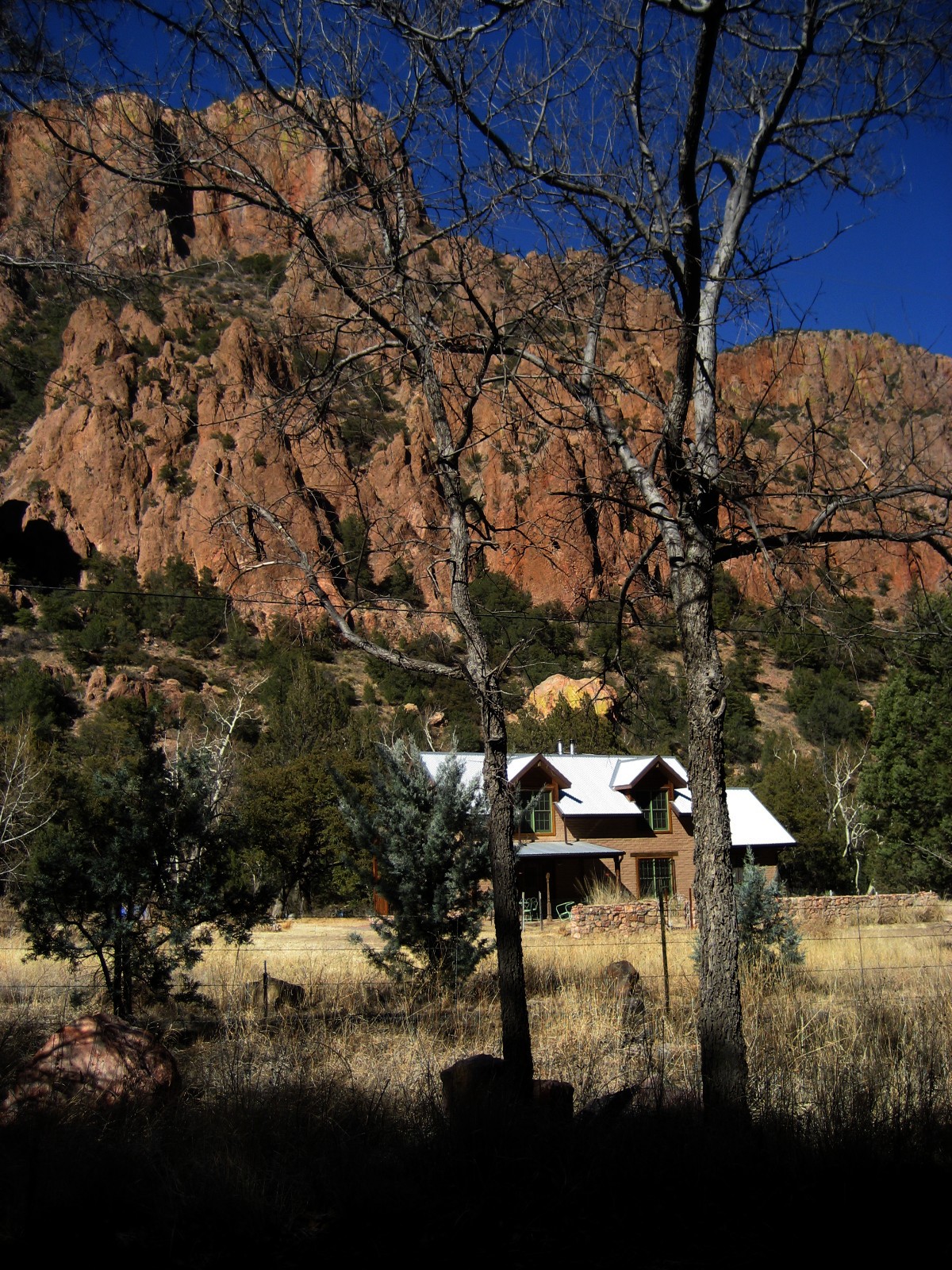
As always, I like to see the mountains in the distance, framing the broad plains. Below I consider the hitchhiker:


Did you see him? Oh, I will miss the humble, hard-working soaptree yucca when I quit New Mexico.

I hoped I'd see evidence supporting the existence of this sign, but I only saw cattle, ravens, and a roadrunner or two:

Highway 81 between Hachita and Antelope Wells, New Mexico


I did see a helicopter sitting daintily in a road pull-out, along with several other vehicles. Not Border Patrol - an energy company, I believe; don't recall the name. Later, on my return from Antelope Wells, the same copter made several trips to/from the road turnout, seeming to come and go over a nearby mountain range.

Highway 81 between Hachita and Antelope Wells, New Mexico


Eventually, I arrived at the end of the road - the edge of the United States. It was confusing which way to go to cross the border. I was presented with a fork in the road. A painted line seemed to direct me to the left, where stood the spanking new border facility, consisting of a large building, a tollbooth structure and a raising/lowering arm that keeps a vehicle stopped at the booth til the driver fulfills whatever border-crossing things s/he needs to fulfil. But straight ahead was a small building, with plate glass that had been broken and was now taped, and which looked like an abandoned service station. But the Stop signs were facing toward Mexico, it seemed. I saw no signs of life.

This was one of those moments where, if you had someone in the car with you, you'd say, "Huh, what are we supposed to do here"? "What do you think we should do"? You take heart in the other person either affirming your befuddlement or taking charge, pointing in one direction, and saying, "Go that way." Because I was alone, however, I just stopped and asked myself these questions.

I went left toward the new complex. When I got to the Stop sign, I stopped. There was also a sign that instructed drivers to STAY STOPPED until given the authority to move forward. I saw the arm thingie up ahead, in its upward stance. Although I felt very stupid, STAYING STOPPED, I again considered my situation. Go? Stay? Back up? I looked over to the dilapidated, abandoned-looking squat structure that I'd eschewed. Still no life signs. Was the border just sort of open this afternoon? It was getting close to lunchtime. Maybe you get a free pass between noon and one?

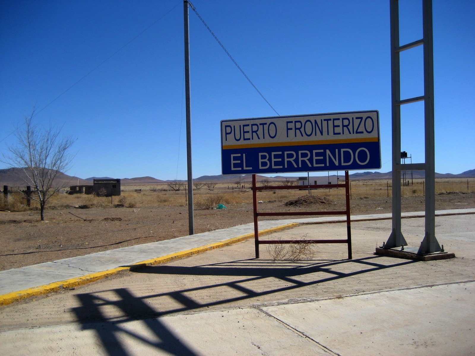
I decided to proceed. I drove past the STAY STOPPED sign, went by the raised arm, drove by the abandoned-looking structure with the taped plate glass, and on into Mexico. OK, then! I was welcomed into Mexico by sign, specifically El Berrendo.

Border between Antelope Wells, New Mexico, and El Berrendo, Mexico


I saw one Mexican Border Patrol man approach from ahead of me, and then another man emerged from a small building to my side. I rolled down my passenger-side window. "Hi!" I said. We both exchanged some inanities, and then he asked what I wanted to do - continue or what? I said I thought I'd just turn around. And he said OK. And then I asked, "Is there a bathroom"? And he directed me back over the U.S. line.

And, by the way, this is the first thing one sees when crossing over into the U.S.:

Border between Antelope Wells, New Mexico, and El Berrendo, Mexico


So I did a 3-point turn and nosed back over the border to the dilapidated building with the taped plate glass window. And now I saw some action. A U.S. Border Patrol came out of the building and we went through the formalities. Another man came out and I gave him my passport, which he took into the little building. The first man asked me if I've got any weapons, drugs, or fruit. I allowed as how I'd brought an apple with me for my lunch. He asked to see my bag and I showed him and he looked into it. I noted wryly that it had come from Walmart. (And I was thinking that the apple had probably been imported from Mexico, but I didn't think it would add anything to our conversation to say that aloud.)

Border between Antelope Wells, New Mexico, and El Berrendo, Mexico

 
The Border Patrol noted that because they'd seen me go over to Mexico and come back, that the apple was OK, but otherwise, bringing back fruit is illegal.

Border between Antelope Wells, New Mexico, and El Berrendo, Mexico


The legalities completed, I asked my final question: "Do you have a bathroom"? And, you know, they did. Right inside. (Which experience reminded me, happily, of another bathroom on another border.) And there was a jar of candy on the counter. And the Border Patrol offered to give me a passport stamp.

Antelope Wells, New Mexico, passport stamp


Overall, a pleasant exchange.

On my way back to Lordsburg, I stopped at the Continental Divide Trail sign-in stand, which is about 30 miles north of the border.

Continental Divide Trail near Antelope Wells, New Mexico

  
I added my name to the bottom.

Continental Divide sign-in list, 30 miles north of Antelope Wells, New Mexico

(Again, I recommend The Walkumentary, a documentary about a group's 2006 hike from the beginning to end of the CDT.)

 
Continental Divide Trail near Antelope Wells, New Mexico
 

On my way back to civilization, I spied a cowboy.

Cowboy, Highway 81 between Antelope Wells and Hachita, New Mexico


I pulled off the road for my packed lunch - a sandwich, some Cheerios, and an apple. Watched that helicopter come and go.

Along a stretch of Highway 81 is a wide river of silvery grass.


And this looked to me like a painting in motion:


When I arrived at the crossroads of Highway 9 and 81, where Hachita sits, I followed 9 to 113 and went up north to Lordsburg. I saw a crowd of tumbleweed refugees. I know they're rather a menace, but they have a beauty.  And endearing character, too.

A crowd of tumbleweeds, Highway 113, between Highway 9 and I-10, New Mexico

I passed an abandoned winery, too.

Defunct winery, Highway 113, between Highway 9 and I-10, New Mexico


Defunct winery, Highway 113, between Highway 9 and I-10, New Mexico


A satisfying day.